Driving down Mission Street, one may see changes in the coming years – more people strolling the sidewalks, a decrease in high-speed traffic, and much more. That’s because one of the objectives of the Mt. Pleasant 2050 Master Plan is reimagining Mission Street.
Mission Street has served as the business route through the city since the US-27 (now US-127) freeway bypass opened over half a century ago; however, during those years, the city has grown and changed. While reimagining it now may seem a lofty endeavor, it’s one that is welcomed by those involved.
“There’s a spirit in the plan of problem solving, finding solutions, and not shying away from problems because they’ve been difficult to change in the past or because they’re large in scale,” says Jacob Kain, Mt. Pleasant city planner.
Making Mission Street more local
One of the primary ways Mission Street is being reimagined is to find solutions that help it serve its current primary function – a local street that is used by local citizens.
“For those of us who live and work here, the purpose and function of Mission Street isn’t just as a pathway through the community,” says Kain. “Analyzing the data, when you look at how the corridor is utilized, it’s really utilized by folks in the community to travel within the community, not through the community.”
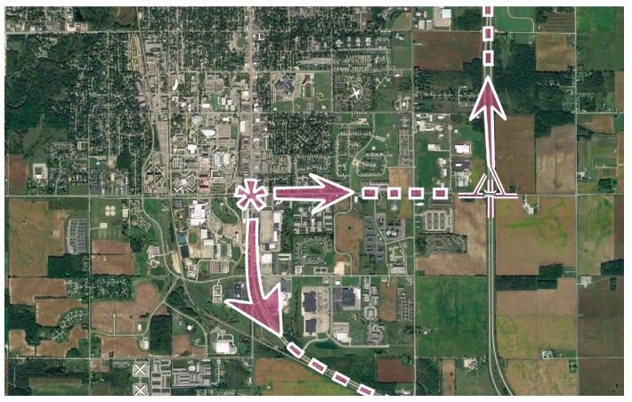
![]() The creation of additional exit ramps at Broomfield and U.S. 127 will support the City’s goals to retrofit Mission Street as a place to go “to” rather than “through.”
The creation of additional exit ramps at Broomfield and U.S. 127 will support the City’s goals to retrofit Mission Street as a place to go “to” rather than “through.”
To that end, the Mt. Pleasant 2050 Master Plan includes northbound and southbound access to US-127 from Broomfield Street. The plan states, “Northbound traffic leaving Mt. Pleasant directly from the university area, and traffic destined for the university area originating from the north, would no longer be required to traverse the entire Mission Street corridor. Eliminating this through traffic would allow Mission Street and East Campus Drive to work as a system with the two streets linked together by the grid of connecting streets as proposed in the 2012 Transportation Network Plan. This would allow the design of Mission Street to safely accommodate a more local function.”
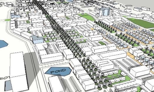
![]() View of Mission Street looking SouthKain says this idea was also included in the 1987 Master Plan, but was unable to come to fruition, reflecting back that one of the exciting aspects of the Mt. Pleasant 2050 Master Plan is that it doesn’t shy away from difficult problems.
View of Mission Street looking SouthKain says this idea was also included in the 1987 Master Plan, but was unable to come to fruition, reflecting back that one of the exciting aspects of the Mt. Pleasant 2050 Master Plan is that it doesn’t shy away from difficult problems.
“It would be looking to add an opportunity there to enter and exit the freeway. It wouldn’t be a replacement of, it would be an addition,” says Kain.
Just as many aspects of the Mt. Pleasant 2050 Master Plan, making this a reality will take collaboration from many interested parties, says Nancy Ridley, Mt. Pleasant City Manager.
“It takes collaboration with the Michigan Department of Transportation, certainly CMU, and businesses up and down Mission Street,” she says. “There’s also the impact on the Isabella County Road Commission with the county roads that intersect with it and Union Township that surrounds the entire city. That makes it a bit more complex, but gives us a great opportunity to work with our partners on such an impactful project.”
Creating a mixed-use corridor
Another primary objective of reimagining Mission Street is to think of it as a vibrant, mixed-use corridor that serves as the entrance to the community. To that end, a series of roundabouts have been proposed at the intersection of East Campus Drive, and Broomfield, Preston, and Bellows Streets.
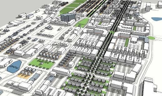
![]() View of Mission Street looking North“The roundabouts would establish a sense of arrival and of place to the district. Working in tandem, roundabouts along Mission Street and East Campus Drive would moderate vehicular speeds, improving traffic flow and maintaining visibility for Mission Street businesses,” states the Mt. Pleasant 2050 Master Plan.
View of Mission Street looking North“The roundabouts would establish a sense of arrival and of place to the district. Working in tandem, roundabouts along Mission Street and East Campus Drive would moderate vehicular speeds, improving traffic flow and maintaining visibility for Mission Street businesses,” states the Mt. Pleasant 2050 Master Plan.
It is hoped that with an additional US-127 ramp on Broomfield to divert some traffic off of Mission Street, as well as roundabouts improving traffic flow, and both measures helping slow traffic down on Mission Street, safe access to businesses will also improve.
“One of the objectives is to provide safe, reliable access to businesses,” says Kain. “That’s been top-of-mind.”
Ridley says she thinks developing Mission Street into more of a mixed-use corridor would be of benefit to the community as a whole – particularly due to the city’s central location.
“Because of Mt. Pleasant being somewhat of a regional shopping destination for the area, it has the potential to offer additional options for shopping that people don’t currently have for the types of stores or restaurants that are currently available to them,” she says.
Making Mission Street pedestrian-friendly
High speeds of traffic frequently seen on Mission Street, as well as other factors, play into a lack of current pedestrian activity on Mission Street.
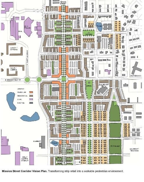
![]() A vision to transform strip retail into a walkable pedestrian environment“Part of the feedback we heard from the community during the early planning process was that individuals didn’t necessarily feel safe walking on Mission Street and that it wasn’t a very inviting place to walk,” says Ridley.
A vision to transform strip retail into a walkable pedestrian environment“Part of the feedback we heard from the community during the early planning process was that individuals didn’t necessarily feel safe walking on Mission Street and that it wasn’t a very inviting place to walk,” says Ridley.
The above-mentioned measures – roundabouts and an additional US-127 ramp – are some of the actions in the Mt. Pleasant 2050 Master Plan to make Mission Street a safer place for pedestrians. To make it more inviting for pedestrians to shop, the plan also states, “in order to keep retail districts within lengths manageable for pedestrians, retail activity is concentrated at intermittent nodes along the Mission Street Corridor.”
Ridley says she hopes making Mission Street more pedestrian-friendly will not only benefit pedestrians, but businesses and, by default, the community as a whole.
“Our hope is that as it becomes more pedestrian friendly it would attract different and maybe additional customers to the locations along Mission Street.”