In southeast Michigan, there are no great mountain ranges or ocean vistas to inspire painters, photographers, or poets -- there isn't even a sand dune. But our region is full of environmental wonders not found in spectacular scenery, but
in the discovery of generally unseen places and the restoration of essential land and water once exploited by industry.
In 1701, Antoine de La Mothe Cadillac described the land along the strait connecting Lake Erie and Lake St. Clair
as "so fertile" with a climate "so temperate." Today, however, only a few remnants of the old growth forest and native prairies he saw survive. As the the region's strategic waterways gave rise to industry -- first fur and lumber, later iron, steel, and automotive -- wetlands and fish habitats were destroyed. Only one mile of the Detroit River shoreline remains unaltered from its natural state today.
In the postindustrial era, however, the region's natural wonders are being rediscovered and restored. While the algae bloom contamination of Lake Erie has intensified concern among residents and elected officials regarding the frailty of our ecosystem, other measures are proving successful at strengthening it. The cleansing of the Detroit and Rouge rivers -- far from complete -- has seen the return of lake fish. Beavers, sturgeon, and the common tern are among the native species reacclimating to their old territory. Landscapers are redeveloping river shoreline, wetlands, and rain gardens to mitigate the negative effects of stormwater runoff, and governmental agencies are recognizing the economic potential of "green" and "blue" nature. Even corporations are being recognized by groups like the
Wildlife Habitat Council for their environmental stewardship.
But there is still much to be done. To call attention to the unique ecology of our region and encourage environmental stewardship, we present our "Seven Environmental Wonders" of southeast Michigan.
St. Clair River Flats and Pointe Mouillee Marsh
![]() Located the northern and southern edges of the region respectively, these two locations share the distinction of being the largest freshwater delta and largest wetland restoration project in North America.
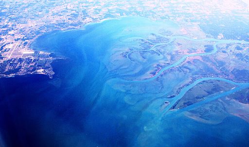
The largest delta in the Laurentian Great Lakes system
Located the northern and southern edges of the region respectively, these two locations share the distinction of being the largest freshwater delta and largest wetland restoration project in North America.
The largest delta in the Laurentian Great Lakes system, the St. Clair River delta is the located at the mouth of the St. Clair River and consists of seven channels, resembling the Mississippi delta in shape. There are 11 islands in the delta, six of which are part of the
Walpole Island First Nations territory.
St. John's Marsh, a wildlife refuge area and hunting zone, is a lake plain prairie designated as a "globally imperiled ecosystem."
In southern Wayne County, off Rockford, environmental engineers created one of the largest freshwater marsh restorations in the world at Pointe Mouillee. The area is the focal point of waterfowl migration, with an estimated 20,000-26,000 birds passing through annually. It is recognized as an "International Shorebird Importance Area." Just as it is a visual spectacle for birders, it's also attractive to hunters and muskrat trappers -- muskrat being a delicacy dating back to the French voyageurs. The
Point Mouilee Waterfowl Festival draws 10,000 tourists annually.
Detroit River International Wildlife Refuge
![]() Humbug Marsh, Detroit International Wildlife Refuge
The only such international designation for the United States and Canada, the refuge
Humbug Marsh, Detroit International Wildlife Refuge
The only such international designation for the United States and Canada, the refuge consists of 48 miles of Detroit River, including 6,000 acres of islands, coastal wetlands, marshes, and shoals. The refuge, managed by the U.S. Fish and Wildlife Service, boasts of two distinguishing features: It is both the hawk migration and walleye spawning capital of North America. In September, as many as 100,000 hawks will hover over the Detroit River, while 10,000 walleyes spawn each spring. The area has also noted the return of beaver, sturgeon, and common tern.
John Hartig, Refuge manager and author of Bringing Conservation to Cities, marvels at the hawk migration. "It's a (natural) wonder," he says. "(The hawks) rise on columns of warm air, then glide down using thermal energy. This fall we had three days out of one week where we saw 10,000 or more broadwing hawks. The month of September guarantees to be awestruck by raptor migration."
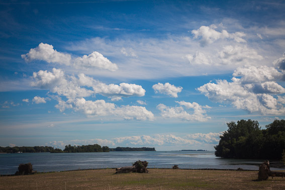
Lake County -- North Oakland County

![]() A lake in Oakland County
It becomes obvious when you begin to see the signs -- "Long Lake," "Square Lake," "Orchard Lake." If you want to live on a lake close to the city, this is where you want to be. It's an excellent example of Michigan's "kettle" lakes -- deep inland lakes created by glaciers which left depressions in the earth filled with melted ice. The county has over 350 lakes, up to 1,280 acres in size. There are also many waterways, including the headwaters of the Rouge and Clinton rivers.
Prairie
Southeast Michigan once had thousands of acres of lakeplain prairie along Lake St. Clair and Lake Erie.Today, less than 10 percent of the lakeplain prairie remains, most of it in Algonac State Park
A lake in Oakland County
It becomes obvious when you begin to see the signs -- "Long Lake," "Square Lake," "Orchard Lake." If you want to live on a lake close to the city, this is where you want to be. It's an excellent example of Michigan's "kettle" lakes -- deep inland lakes created by glaciers which left depressions in the earth filled with melted ice. The county has over 350 lakes, up to 1,280 acres in size. There are also many waterways, including the headwaters of the Rouge and Clinton rivers.
Prairie
Southeast Michigan once had thousands of acres of lakeplain prairie along Lake St. Clair and Lake Erie.Today, less than 10 percent of the lakeplain prairie remains, most of it in Algonac State Park, along the Huron River in Ann Arbor, and a narrow strand on Belle isle. Lakeplain prairies are flatlands that flood in the spring, featuring 160 species of plants.
Humbug Marsh and the Black Lagoon
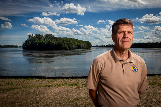
![]() John Hartig, refuge manager, Detroit International Wildlife Refuge
Their names seem to be drawn from gothic fiction, perhaps appropriately. Humbug Marsh
John Hartig, refuge manager, Detroit International Wildlife Refuge
Their names seem to be drawn from gothic fiction, perhaps appropriately. Humbug Marsh, an essential wetland area of the lower portion of Detroit River International Wildlife Refuge, was once targeted for residential development. While it puzzled some why developers would want to build in a marsh, the project prompted community-based environmentalists to fight it. "Citizens led the charge and they won," recalls Hartig. "Humbug Marsh is a wetland of international importance." As Refuge Manager, Hartig recently announced plans to develop a deep water fishing pier in the area.
North of Humbug Marsh in Trenton is an area of the Detroit River known as the "Black Lagoon." Named for a cesspool of oil and grease, the area had been a toxic eyesore for years. However, in 2006-7, a massive shoreline/lagoon restoration project transformed the area into a clean fish habitat and municipal marina, renamed "Elias Cove."
Southeast Michigan Water Trails/Detroit Heritage River Water Trail
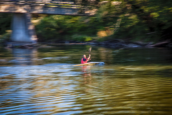
![]() Kayaking the water trail of the Clinton River
The recent (and first) National Water Trails Forum
Kayaking the water trail of the Clinton River
The recent (and first) National Water Trails Forum in Ann Arbor highlighted the southeast Michigan region as having the most water trails of any in the nation. From an ecotourism perspective, this is big. We may no longer be exporting as much natural resources and products as we once did, but we are increasingly moving people along our waterways. The most notorious river in the region is the Rouge, but much attention is being given to the Clinton River, as well. While the region may not have the rapids of rivers in Appalachia or the Rocky Mountains, the Clinton River has a 600-foot drop along its path to Lake St. Clair, featuring class 2 and 3 rapids. The
Great Lakes Restoration Initiative recently announced $20 million for Clinton River restoration.
Fighting Island
This 1,500-acre island, technically in Ontario, was a brine disposal site for Wyandotte Chemical for more than 100 years. In the 1980s, BASF began a 20-year restoration project in which the corporation planted 200,000 seedlings, including poplar, Russian olive, berry trees, and prairie plants in fresh top soil, minimizing brine runoff into the water. Pheasant, turkey, deer, fox, rabbit, owls, and bald eagles have been sighted on the island. The project earned a Wildlife Habitat Council certification. Its north point features a lodge used for corporate events and student visits. Recently, a sturgeon spawning reef was constructed off the island, the first such international endeavor.
Honorable Mentions
There are many other examples of environmental wonders, particularly important restoration efforts, that are slowly returning aspects of the region's ecology to a semblance of the original pre-industrial splendor that Cadillac described at the outset of the 18th century. They include:

![]() Detroit RiverWalk at Miliken Park, home to a native prairie restoration site
Detroit RiverWalk at Miliken Park, home to a native prairie restoration site
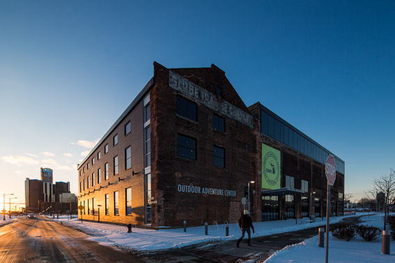
![]() Outdoor Adventure Center
Dennis Archambault is a Detroit-based freelance writer.
Outdoor Adventure Center
Dennis Archambault is a Detroit-based freelance writer.
Photos by David Lewinski. Follow him on Instagram @instagramdetroit.
Photo of St. Clair River Delta by Bjoertvedt (Own work) [CC BY-SA 3.0 (http://creativecommons.org/licenses/by-sa/3.0)], via Wikimedia Commons.
Enjoy this story?
Sign up for free solutions-based reporting in your inbox each week.