Metro Detroit is home to many watersheds, like the well-known historic River Rouge, which has transformed from being a vital resource for early settlers to a heavily industrialized waterway.
This year, the
Friends of the Rouge is focusing on a few efforts to help motivate residents to get to know their backyard river and inform them on how to keep it healthy. Since 1986, the organization has been working to restore the Rouge River through research, workshops, and community engagement.
“Our secret sauce is not saving the river, but that we’re empowering people to be able to then build that relationship to the river — and then to be able to advocate for the river,” says Ashley Flintoff, executive director of Friends of the Rouge.
“We know it’s really bad,” Finding Road Salt in the Rouge River
The Rouge is one of the most urbanized watersheds in the country, expanding across three counties – Oakland, Washtenaw, and Wayne – with over 1 million people living nearby. Much of the river is near industrialized areas with manufacturing plants, making it susceptible to
pollutants like Sodium Chloride.
Sodium Chloride, also known as road salt, has been creeping into the state’s lakes and rivers. A study published in the Association for the Sciences of Limnology and Oceanography found that watersheds with a greater area of roads, parking lots, and other impervious surfaces tended to have
higher chloride levels due to direct runoff into nearby streams and lakes.
Last year, the Friends completed the most comprehensive report on the findings of sodium chloride in a watershed in southeast Michigan. By incorporating Quantab strip testing into their community events, like bug hunts and fish surveys, they found that
nearly 90% of the streams they tested were impaired with salt.
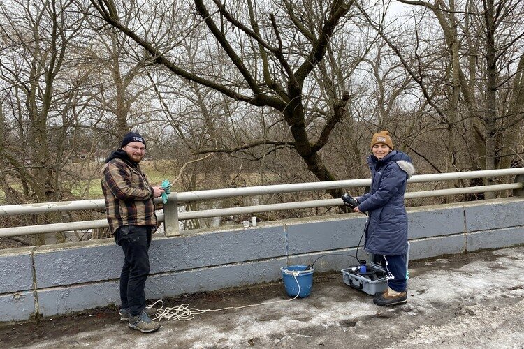
![]() Friends of the Rouge gathering data on Sodium Chloride in the Rouge River.
Friends of the Rouge gathering data on Sodium Chloride in the Rouge River.
Over
2 million tons of road salt are used on Michigan roads every year, and during the testing period, they found that road salt can stay in the watershed for months after it’s used. Road salt is toxic to aquatic life, like macroinvertebrates and fish. Flintoff mentions that the substance could eventually end up in drinking water, too.
With this study, the Michigan DNR and
Environment, Great Lakes and Energy (EGLE) can flag the stream as impaired with salt, hopefully allowing for funding to help mitigate this issue, she says. The Friends' focus this year will be to continue adding to that data and educating other environmental organizations and the public about this issue.
“We’ve got all these numbers and we know it’s really bad, so let’s start to work together on what solutions might be,” she says.
Some of those solutions include incorporating anti-icing Best Management Practices (BMPs) like planting native grasses like Switch Grass and Sand Dropseed, which help remove salt from the soil.
Building Community Partnerships
The organization has spent the last few years developing internal guidelines for community engagement, realizing it’s not easy to enter communities and get them interested in their mission of protecting the river.
The Friends are looking to continue building relationships they’ve already established and add a new approach of asset mapping to understand where they haven’t yet built relationships.
“This year, we are trying to identify communities where we know that there are pressures, where we know there are concerns, and begin to understand who we should be talking to, how we can start to build trust in those communities, neighborhoods, cities,” Flintoff says.
One way they do that is by building the
Lower Rouge River Water Trail. The Friends are working with 10 local communities and Wayne County to develop a 29-mile network of connected greenways from Canton to the Detroit River. This
project will provide access points like canoe and kayak launches so folks can safely paddle the river, educational signage along the trail, and allow for easy monitoring and management of water quality and wood debris.
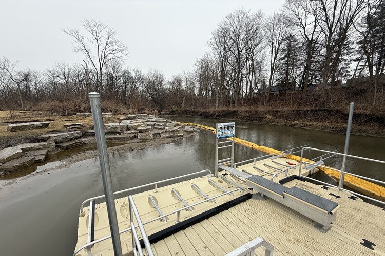
![]() Venoy Dorsey Park's new canoe and kayak launch.
Venoy Dorsey Park's new canoe and kayak launch.
“The work is done in tandem with community partners and like-minded business organizations,” says Herman Jenkins, the trails manager for the organization. “Community engagement plays a critical part in that and making certain that the community has their footprint on what these spaces look like and feel like, and hopefully reflect the interest of the people who live there.”
With many communities like Dearborn and Allen Park having blocked access to the river by industrial buildings, the hope is that this project will increase people's ability to interact with the watershed.
![]() Herman Jenkins.
Herman Jenkins.
Nine trailheads are shovel-ready, but only two will open this summer — one at Venoy Dorsey Park in Westland and the other at Fort Street Bridge Park in Detroit, which will be the city’s only access point to the water trail.
“We have to build it in pieces like one big giant Lego set,” he says.
These access points will allow them to connect with folks through efforts like the
Dry Dock Pop Up by attending farmers markets, festivals, and other events to share tips on water safety and updates on the Blue Water Trail.
By having access to these trails, there’s also an ability to grow the community's businesses, similar to other projects like the
Clinton River Trail, Jenkins says.
“We’re hoping that a blue economy can rise, having a world-class destination water trail,” he says. “On the lower Rouge, there are instances where these things can potentially grow.”
The next communities the Friends hope to work with to continue their work of building the trail are Allen Park and Melvindale.
“It’s coming to life,” Jenkins concludes.